|
Cover Story
Where is Assam?
Instead of accepting the
nationalisation of everything by political boundaries, we can
use geographical history to locate current social
realities.
by |
David
Ludden
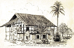
Tea
planters bungalow, Khorbhat tea estate, Assam, India
(E. Goodall, 1935) |
Assam is today a state of India and, as such,
an official region of a world entirely covered by nations and
encompassed by national maps. We have no choice but to locate
any region like Assam inside of national geography, for this
both controls our spatial imagination and conveys a specific
location, identity and meaning.
But other perspectives do exist. Despite the
seemingly universal authority of national geography, the
location of social reality is flexible. That Assam is part of
India is indisputable; but it is important to note that this
fact coexists with others that find different locations for
Assam. Indeed, looking at any areas geography in slightly
less conventional ways allows for the appearance of a
kaleidoscope of social realities. Such an understanding allows
for important new frames of reference for scholarship,
activism and policy-making.
The first step is to appreciate the political
nature of all modern maps. Territorial boundaries as well as
social efforts to define, enforce and reshape them represent
political projects rather than simple facts. The makers and
enforcers of boundaries use maps today to define human reality
inside of national territory. As a result, everything in the
world has acquired a national identity. We see the boundaries
of national states so often that they almost appear to be
natural features of the globe.
This virtual reality came into being only in
the 19th century, as various technologies for surveying the
earth, mass-printing, mass-education and other innovations
began to make viewing standardised maps a common experience.
Making maps, reading maps, talking about maps, and thinking
with mental maps became increasingly common with each passing
decade. By the 1950s, people around the world had substantial
map-knowledge in common. Today, we can reasonably imagine that
most people in the world share common map-knowledge because
they routinely experience various versions of exactly the same
maps. During the global expansion of modern mapping, national
territory suddenly incorporated all of the earths geography.
Though national boundaries only covered the entire globe after
1950, within a decade or two all histories of all peoples in
the world came to appear inside national maps, in a
cookie-cutter world of national geography. This has been the
most comprehensive organisation of spatial experience in human
history. Spaces that elude national maps have now mostly
disappeared from intellectual life.
Maps attain their form and authoritative
interpretation from both the political economy and the
cultural politics of mapping; the most influential people in
these processes work in national institutions, including
universities. State-authorised mapping is now so common that
most governments do not regulate map-making, but almost
everyone draws official lines on maps by habit anyway. Indeed,
this dynamic is so pervasive that few people ever even think
about it, yet it has covered the planet with the nation
states territorial authority. As a result, we are now
accustomed to seeing maps that nationalise topography by
erasing spaces on the edge of a nations identity. In India,
this includes several major spaces near Assam areas in
Nepal, Bhutan and Bangladesh which have become mostly blank
spaces in the countrys national view of Southasia. Every day,
TV and newspaper weather maps nationalise rainfall, wind and
the seasons, by enclosing them inside national boundaries.
This seemingly innocent nationalisation of nature makes it
increasingly difficult to visualise any world not defined by
national boundaries.
After understanding the political nature of
maps, our second step is to appreciate the extent to which
modernity depends on the idea of national territories. The
whole notion of modern statistics, for instance, could only
come into being inside frozen, unchanging geographical
spaces.
This freezing of blocks of space inside nations
had already begun by 1776 (when Adam Smith published The
Wealth of Nations), with the assumption that every nations
wealth belonged inside its national boundaries and under the
control of its national government.
Fixing regions in place inside national maps
brought to modern social life a newly rigorous, compre-hensive
order. Today, national maps describe the location of every
single thing, person and place on the planet.
National territory also heavily affects
cultural politics, both inside and across national boundaries.
Human identity everywhere is attached to national sites; in
those places, some people are always native, while others are
always foreign.
In the Indian context, Assam is a part of a
region officially called Northeast India It has much more
geographical contact with other nations than with the Indian
mainland, however, from which it is most often described as
remote. Assam is also grouped with state territories in
northeastern Southasia described by the South Asia
Foundation as
the eastern states of India, Bangladesh,
Bhutan and Nepal which has a definable population, GNP,
land area and trade history. This relationship alone allows us
to move our perspective around and to reconfigure Assams
geographical location. Following this strategy into the past,
step three in this process looks at geographical perspectives
that move along routes of movement, blending them together
over history.
This method is actually quite realistic. After
all, however natural, necessary and comforting it may seem to
assign everything in the world a fixed location, doing so
inside of firm boundaries can never succeed in creating a
stationary social order. Most of the time, everything in
social life is on the move, in a way that national geography
cannot accommodate. By considering how trends of mobility have
changed throughout history, we can locate Assam in a more
flexible geography.
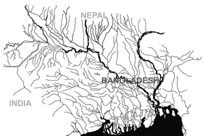
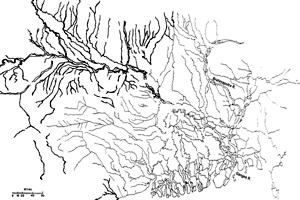
Assam-in-Asia
Nature is a
good place to begin. An especially good place to begin is a
river, as defined by the naturally downhill movements of
flowing water. In such a water-view of the world, Assam lies
in Asian spaces defined by mountains, slopes and plains. These
monumental features channel the rains that arrive with Asias
longest, wettest monsoons and feed the extensive valleys where
rice became the dominant crop by around 1500 AD. In this wet,
river- and rice-fed Asia, human populations have historically
moved into and concentrated in river valleys and their
adjacent areas. Assam has long been a region of in-migration,
hosting new generations of settlers from prehistoric times to
the present day. With low-density mountains on three sides,
Assam is the eastern edge of the exceptionally high-density
Gangetic population zone that runs from the hills of Punjab to
the Bay of Bengal.
The impact of this water-view of Assam-in-Asia
becomes immediately clear on the geography of river
development projects today. All Indian rivers running through
Assam also flow into Bangladesh; throughout these watersheds,
people depend on the same water. Major dam projects disrupt
that geographical reality. The proposed Tipaimukh dam in Assam
and, more dramatically, Indias plan to divert Assamese waters
to parched Indian regions would reduce the flow of water into
the delta. It is little wonder that such plans arouse concern
(and outrage) in Bangladesh, which gets 80 percent of its
fresh water through 54 rivers flowing from India.
Assam also occupies a borderland of Asian
drainage systems, sitting astride a watershed that divides the
western trajectory of the Brahmaputra at the Patkai Range from
major drainages of Southeast Asia and southern China. Five
huge rivers define the major corridors of settlement and
mobility running from the Ganga basin across China, Vietnam,
Thailand and Burma. The Brahmaputra (or Jamuna in Bangladesh)
is the easternmost river of Southasia, but it is also the
westernmost in East Asia. In this context, Indias Northeast
is commonly found on maps of East Asia. Assam and the rest of
the Northeast, as well as the adjacent Chittagong Hill Tracts
in Bangladesh, can subsequently be seen as a western region of
East Asia, an eastern region of Southasia, and as a region
where South and East Asia overlap. It is this overlapping that
is impossible to accommodate on national maps; it thus
effectively disappears from the public conscious.
From ancient times, the NE-SE course of the
river valleys east of Assam has channelled human movement
inland through Southeast Asia and China. In Assam, important
such historical channels have included: the routes of the
ancient Khasi and Tai-Ahom migrations, which moved westward
from the Red River basin in Vietnam; the routes of opium
trade, with unknown origins but which extended from Bihar to
China; the imperial expansion of Burma; and the military
travels of the Chinese, Japanese, British and Americans along
roads from Assam to Yunnan, during the 1940s.
River routes have long connected Assam in each
direction. The major movements that decisively shaped the
region in early modern times (1660-1830) included: the Mughals
and British moving northeast from Bengal; the Ahoms moving
down the Brahmaputra basin; Burmese armies moving around the
Patkai and across the Nagaland ranges; and trans-Himalayan
forces coming south from Nepal, Bhutan, Tibet and China.
Before 1800, Indian Ocean routes seem to have
had less direct impact on the Brahmaputra valley than on other
Southasian regions comparably close to the coast. Most
importantly for its geographical history, however, by 1800
Assam lay at the intersection of Indian Ocean routes with
inland routes into interior East Asia. Thus, early British
imperial geographers believed with some justification that
Assam was Indias inland gateway to China. Opium and tea,
among other commodities, already travelled Indo-Chinese roads
through Assam. When Europeans discovered India and China,
however, they did so at seaports; here they imagined all
societies as being attached to separate inland civilisations.
From this seacoast view of northeastern India, ethnic groups
in the mountains looked more like East and Southeast Asian
peoples than like those that dominated the Indian lowlands.
Thus, Europeans viewed East Asian-looking peoples in Northeast
India as marginal or even alien to the surrounding Indic
civilisation. These mountain ethnic groups, however, actually
represent the historical overlapping of social spaces,
defining Asia from the west and east at the same time.
British Assam
Our national
traditions of geographical knowledge do not pay equal
attention to all of the routes of human mobility that shaped
Assam. Indian historical geography focuses exclusively on
routes that run east-west along the Gangetic basin, where
dominant social groups have always identified Assam with
eastern frontiers. In the Indian national view, Assam has
always been an Indian frontier, always in the process of being
incorporated into Indo-Gangetic history. Even when the British
Empire began its northeast expansion from Sylhet and Cooch
Bihar, Assam still lay on cultural and political frontiers of
South and Southeast Asia.
 |
Guwahatis relations with New Delhi, even
today, represent a dynamic that began under the Gupta Empire
in the early centuries of the first millennium. Like the
Mauryas before them, the ancient Guptas carried their imperial
ambitions far from their homeland in Bihar, but also much
farther west than east lands to the east of the Ganga basin
being considered undesirable. Gupta culture later influenced
the Assamese Kamrupa kings in large part through trade.
Indeed, the Buddhists who dispersed across eastern frontiers
flourished there for centuries, in part because trade, rather
than imperial power, extended across the water routes of
Bengal.
A thousand years after the last of the Guptas,
the strength of Ahom warriors in the Brahmaputra basin,
combined with the difficulty of forests and raging river
waters, largely kept Mughal imperialism at bay. During the age
of Ahom rulers in Assam, the Mughal Empire was rooted in the
far west. The renowned Mughal gardens derived from desert
ideals in Central Asia and Iran; Mughal homesteads blended the
cultures of Persia and Rajasthan. Lands of dense forests, deep
annual floods, rivers, tigers, elephants and fearsome mountain
warriors proved too difficult for the dry-land plains warriors
to conquer. These lands paid very little imperial taxation
anyway. As such, the Mughal padshah and his nobles mostly
conquered and sported on the fringes of forest tracts that
they left to local rulers, from whom they extracted as much
obedience and tribute as possible.
Assam became part of imperial India only after
the Mughals lost their grip in Bengal, as British imperialists
expanded inland from the sea with a combined force of
merchants, armies and Brahmans. Northeast of Calcutta, Mughal
highways pointed to Assam; but because Assam lay outside of
Mughal control, it remained so for early British India as
well. Only once the British conquered Assam in 1826 did the
area obtain for the first time in its history a firm
regional identity as a part of Indian imperial geography.
Until 1874, British Assam was part of a novel imperial
territory called Bengal, which included West Bengal, Bihar,
Orissa, Jharkhand, Northeast India and present-day Bangladesh.
British Assam always included the Brahmaputra and Barak river
valleys, as well as the Surma-Kushiara river basin of Sylhet.
After 1860, the tea industry spread across hills around these
rivers and enhanced control of the administrative unity of
Sylhet and Assam.
Until 1947, British Assam was an eastern
borderland of British imperialism, which tried to incorporate
Burma and never quite established full control over the
mountains between India and China. In the context of British
India, Assams Brahmaputra valley had special strategic
significance as a borderland between British India and
imperial China (until 1911) and Japan (1939-1945). In 1947,
Assam became Indias nearest borderland with revolutionary
China. In this strategic location, the US Army built the
so-called Stilwell Road in 1943 running from Ledo in Assam
to the China-Burma road as a supply link with the Bengal-Assam
Railway for the US and British wars against Japan and, later,
the Chinese Communists (see Himal Sept-Oct 05 article on the
Stilwell Road). War along this road was intense. Recently,
Indian investigators found as many as 1500 graves from the
World War II era on the India-Burma border along the Stilwell
Road.
Partition and after
The
year 1947 dramatically changed the forces shaping Assam.
Partition and its fallout resulted in the cutting and
restriction of traditional routes around Assam, and introduced
major demographic changes. Together, these two forces give
Assam the shape and location we see today. Most importantly,
the formation of East Pakistan (and later Bangladesh) created
new national borders with a presumed hostile state to Assams
west and south. In Assams southeast, Sylhet was the only
region of British India where a referendum was held
specifically on the question of accession to India or
Pakistan; in 1947, the vote in favour of Pakistan separated
Sylhet from Assam for the first time since 1826.
Partition also exaggerated a process of change
in the cultural composition of the Sylhet population, which
had proceeded slowly for at least 50 years after the first
Indian census in 1871, when the Muslim and Hindu populations
had been roughly equal in number. After 1871, migration into
Sylhet farming regions increased the Muslim population with
every census. Between 1891 and 1931, people reportedly born in
the Bengal District of Mymensingh but living in Assam
increased from one-third to two-thirds of the population of
southern Assamese valleys, including Sylhet. Noting this
upward trend in migrant settlement, in 1931 the Assam Census
Report called Muslim Bengalis in Assam invaders. To defend
their territory against this invasion, the Assam Congress
resolved to move Sylhet out of Assam. The question of how to
regulate migration into Assam from Bengal dominated the state
political agenda in the 1930s and 1940s. After 1947, this
topic became a new type of national issue, with reference to
alleged threats to national security.
Migration continued to increase after
Partition, however, and remained high for three decades,
spurred in part by wars in 1965 and 1971. In the 1960s, the
total Sylhet population rose 60 percent as one lakh Muslim
Bengalis moved out of Assam into Sylhets Haor basin, where
open land was available. Sylhets population growth was most
dramatic in areas nearest Meghalaya and Tripura, where
migration produced completely new localities filled with
immigrants. In much of Sylhet, a new social formation emerged,
which ranked the cultural status of old and new residents a
dynamic that continues today.
Although the ethnic composition of the
population had been a political issue in Assam since the
1920s, it raised its head again after 1950. Assam then shrunk
in size for two reasons: first, Partition cut out the
mostly-Muslim Sylhet; second, nationalist territorial claims
by ethnic groups produced the mountain states of Meghalaya,
Mizoram, Nagaland and Arunachal Pradesh. The boundaries of
Assam, Arunachal Pradesh and Nagaland are still contested
today, representing a tug-of-war over ethnic claims to natural
resources marked by state territory.
Trends in population change, the creation of
territorial borders and the mobilisation of ethnic politics
have indeed occurred throughout the Northeasts much longer
history. This has historically moved people into more densely
populated areas that then expanded physically upwards, moving
from the lowland plains and valleys into the surrounding hills
and mountains; during that advance, large populations have
absorbed various ethnic and tribal groups. In the century
after 1880 (when statistics appeared for the first time), the
expansion of permanent cultivation proceeded at extremely high
rates in Tripura, Nagaland, Sikkim and Assam faster than
almost anywhere else in Southasia, in fact. Most of this
expansion appears to be the result of lowland farmers
investing in land at higher altitudes. During this process,
Tripuris became a minority in Tripura, where mostly Hindu
Bengalis became dominant. A similar change occurred more
recently in the Chittagong Hill Tracts, where Muslim Bengalis
became numerically dominant, triggering resentment and revolt
among the regions ethnic groups.
Such transformations of social space moved
investors and residents in 1947 into open areas still
available for agricultural colonisation. Huge tracts of land
remained free in forested regions of eastern and, especially,
Northeast India. Indeed, this became one of the last
agricultural frontiers in Southasia, where new farming
communities were able both to improve their living conditions
and to enhance national wealth. The physical expansion of
cultivated farmland remained the major source of increases in
Southasian agricultural production until 1960. Population
densities increased very rapidly in these frontier areas,
where, until 1880, people settled at an even greater pace than
into urban areas although most upland agrarian frontiers
maintained very low population densities, which continues
today.
The stubbornness of territorial
anxiety
Against this backdrop, however, even in
regions typified over many centuries by extensive mobility,
national governments and popular movements worked harder after
1947 than ever before to close off and regulate traffic across
national borders. Their goals were twofold: to defend national
territory against foreign threats; and to suppress internal
disruption that might be fed by crossborder forces. Indias
Northeast became an exposed territory, facing alien states
around most of its perimeter. Defending Indias borders meant
closing off the Northeast against crossborder threats. In
Assam, a regional political movement also tried to close
borders to alien immigrants, particularly from Bangladesh.
Today, the Bharatiya Janata Party again reiterates this
rhetoric.
New political efforts are now working against
the trend of national enclosure, however. Today, civil society
in Bangladesh is pressing its government and India to keep in
mind the real-life implications of rivers that run through
Assam and on into Bangladesh. State governments in the Indian
Northeast are also calling for a reopening of trade routes
along the old Burma-China Road, which would benefit landlocked
state economies that currently face international barriers on
three sides. At the moment, New Delhi is expressing
considerable interest in such plans.
Still, Assams continued official isolation
from non-Indian territories is a serious security concern for
the Indian government, now mostly due to the insurgent
problems within the countrys borders. In this respect,
Indias internal order problems are intimately linked with the
virtual impossibility of closing off Assam to the traditional
channels of human movement routes that are much older than
any state in the region. This problem, of course, seems
common-place in todays age of globalisation. While world
regions could benefit economically from simpler crossborder
connections, communities on opposite sides of international
borders would clearly benefit from common attempts to solve
trans-border problems. Nonetheless, national political and
cultural systems remain committed to strong border defences in
the fear of disturbing the coherence of their national
traditions. Indeed, the conflict between these two pressing
modern needs territorial openness and closure seems
increasingly difficult to reconcile.
So, where is Assam?
From
the above perspectives, a useful answer to the question of
Where is Assam? would be that Assam consists of all that has
left traces in the valleys and mountains around the
Brahmaputra and Barak rivers. In this view, locating Assam
requires that we trace the mobility of all of those elements
over the span of human history; after so doing, we can
discover the geography where those elements most meaningfully
overlap. While this would provide us with a good picture of
Assams location, it would not be one picture, but many
leaving the problem of actual location open for debate and
endless research. Clearly there are numerous obstacles to
thinking about geography in this way. At the moment, national
borders simply dont function like this (although people may
indeed be better off in regimes that would permit them freer
mobility).
 |
Plans for a new Asian Highway would put Assam
at the centre of a new Asian transport system and would take
the state from the periphery to the centre of a new
territorial formation in Asia. But progress on the highway is
now stalled, due mostly to Indo-Bangladeshi disputes over
border issues, illegal immigrants, and terrorism allegations.
Against this backdrop of hopes for expanding mobility and
integration, however, it is worth remembering that new
national borders are, in the long span of history, typically
imperialist dreams. So it was in the days of the Guptas,
Mughals and British, and so too when the US Army built the
Stilwell Road to counter imperial Japan.
It is not surprising, then, that since 1945,
independent nations have generally increased the regulation of
traffic across their borders. Hostilities between India and
Pakistan have cut old routes of communication and mobility
more dramatically than almost anywhere in the world this in
a region that had maintained highways from the Mediterranean
for a millennium. Elsewhere in Southasia, the Bengal-Assam
railway tracks from Guwahati to Dhaka were torn up at the
Cachar-Sylhet border in 1965. Nowadays, it is easier to
communicate by phone or mail between Dhaka and London than
between Dhaka and Guwahati.
In a world of national states it is thus worth
pondering: who is it that sponsors and argues for the opening
of geography and the crossing of national borders? Today,
increasingly diverse interests are engaged in this project
including business groups, who are taking a lead in the
border-crossing movement and promoting the expansion of Asian
highways. Once upon a time, British imperial tea interests
financed the railway from Dhaka to Guwahati and fostered
Bengals integration with Assam to link tea estates to ports
and overseas markets. There is currently no major legitimate
economic interest in place to effectively instigate or finance
a major improvement in the Assam-Burma-China road and other
routes of transit across the mountains. Indeed, the largest
financial interests may be black- and grey-market trades, most
notably in the weaponry that is used in the regions various
struggles. The impetus to open borders across mountains
spanning Nepal, China, Northeast India, Bangladesh and Burma
still seems weak when compared to the pressures of enclosure,
which remain significant. Still, this current dominance only
obscures the compelling ongoing mobility that continues to
locate Assam in the social reality of its Asian
surroundings. |