Volunteers Wanted for Archaeological IllustrationContact:Dr. Clark L. Erickson Department of Anthropology University of Pennsylvania Tel: (215) 898-2282 Fax: (215) 898-7462 cerickso@sas.upenn.edu |
Artists have always played an important role in the presentation of the archaeological record --- from scientific illustration of archaeological materials to the reconstructed depictions or "artist's conception" of buildings, sites, and landscapes. Major advances in computer graphics and drafting technology has permitted archaeologists to make more use of extremely accurate reconstruction drawings of the archaeological built environment.
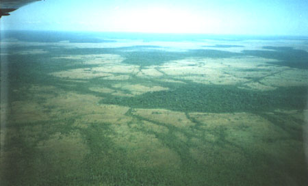
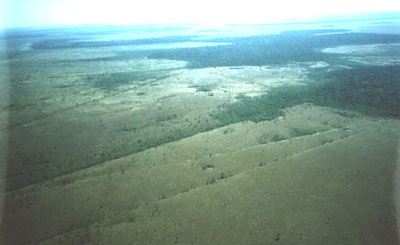
I do research on raised field agriculture, a form of indigenous crop production practiced by farmers in the highlands and lowlands of South America before the arrival of Europeans (Applied Archaeology). The archaeological remains cover vast areas of seasonally flooded lands of Peru and Bolivia. Raised fields permitted high yield agricultural production in marginal zones by draining wet areas, increasing soil depth, recycling and producing organic matter, and improving local climates. Most of these earthworks are badly eroded, although traces can be discerned from the air and from ground survey. Our archaeological studies of raised fields in the highlands of Peru near Lake Titicaca and the tropical lowlands of the Bolivian Amazon have utilized archaeological techniques such as aerial photograph interpretation, excavations, and reconnaissance on the ground and in the air. Additional interpretations were provided by a program of experimental field construction and use. This information has served as the basis for an "applied archaeology" project to promote the rehabilitation of the abandoned raised fields for contemporary use by indigenous farmers of the regions.
I am preparing publications (two books and several articles) which require illustrations of raised field earthworks. I would like to work with some students on this project to investigate various artistic media for depicting these earthworks. I would like to have a group of students investigate the use of CAD programs, various perspective renderings of earthworks based on our ground survey and aerial photographic interpretation. I would like to see CAD used for providing accurate measurements and "wireframe drawings" that could be used as the basis for paintings and drawings. Ideally, the artists would depict local on the fields, farmers in indigenous dress working on fields, and animals in canals and field borders.
I would expect the students to do some research on the project, the regional geography, the peoples, the archaeology, and the crops of the region in order to become familiar with the subject matter to be rendered. I would also like to have the students study other artist's conceptions of archaeological buildings, sites, and landscapes such as those produced for National Geographic, Time-Life Books, Scientific American, and Discover magazines. I may be able to provide access to computers, digitizers, and workspace. I can practically guarantee that the students' work will be published in some form or other. This would be an ideal topic for independently minded students working on Senior year projects. College credit could be arranged.