A “News Focus”
article from SCIENCE
4 FEBRUARY 2000
VOL287:786-789
Are the
mounds, causeways, and canals in Bolivia’s Beni region natural
formations or
the result of 2000 years’ labor by lost societies?
Earthmovers of the Amazon
by
Charles C. Mann
TRINIDAD, BOLIVIA—In some ways, William Denevan says today, he didn’t
know what he was getting into when he decided to write his Ph.D. thesis about
the Beni, a remote, nearly uninhabited, and almost roadless department in the
Bolivian Amazon. Located between the Andes Mountains and the river Guaporé (a
major Amazon tributary), the Beni spends half the year parched in near-desert
conditions and the other half flooded by rain and snowmelt. But it wasn’t until
he made his first research trip there, in 1961, that Denevan realized the area
was filled with earthworks that oil company geologists—the only scientists in
the are—believed to be ruins of an unknown civilization.
Convincing a bush pilot to give him a flying tour, Denevan examined the
earthworks from above. Much of the Beni is covered by a savanna known as the
Llanos de Mojos (the Mojos Plains). But, to his amazement, Denevan saw what
seemed to be the remains of transportation canals, pyramid-like mounds,
elevated causeways, raised agricultural fields, and clusters of odd, zigzagging
ridges scattered through the savanna. “I’m looking out of one of these DC-3
windows, and I’m going berserk in this little airplane,” recalls Denevan, who
is now a professor emeritus of geography at the University of Wisconsin,
Madison. “I knew these things were not natural. You just don’t have that
kind of straight line in nature.”
Today, almost 4 decades later, a small but growing number of researchers
believe that the Beni once housed what Clark L. Erickson of the
University of Pennsylvania, Philadelphia, calls “some of the densest
populations and the most elaborate cultures in the Amazon”—cultures fully as
sophisticated as the better known, though radically different, cultures of the
Aztecs, Incas, and Mayas. Although these still unnamed peoples abandoned their
earthworks between 1400 and 1700 C.E., Erickson says, they permanently
transformed regional ecosystems, creating “a richly patterned and humanized
landscape” that is “one of the most remarkable human achievements on the
continent.” To this day, according to William Balée, an anthropologist at
Tulane University in New Orleans, the lush tropical forests interspersed with
the savanna are in considerable measure anthropogenic, or created by human
beings—a notion with dramatic implications for conservation.
These views have thrust the Beni into what Denevan calls “the Amazon archaeology
wars.” For more than 30 years, archaeologists have clashed, sometimes in
bitingly personal terms, over whether the vast river basin could provide the
resources for indigenous cultures to grow beyond small, autonomous villages.
Until relatively recently, the naysayers had the upper hand. In the last
decade, though, several archaeologists, including Anna C. Roosevelt of
Chicago’s Field Museum, have published evidence that such societies did exist
throughout the várzea, as the Amazonian floodplain is known, and the bluffs
above it (Science, 19 April 1996, pp. 346 and 373; 13 December 1996, p.
1821).
The dispute over the Beni is similar. Using environmental arguments,
skeptics contend that the Beni earthworks must be either natural formations or
the remains of a short-lived colony from a richer part of South America—the
Andes, most likely. “I haven’t seen any basis for thinking there were large,
permanent settlements there,” says archaeologist Betty J. Meggers of the
Smithsonian Institution in Washington, D.C. “But if they were there, where is
the solid evidence?” In particular, critics like Meggers point out, there is no
indication of hierarchical organization in the Beni. Without it, they say, the
kind of sophisticated society envisioned by Denevan, Erickson, and Balée could
not have existed.
Resolving the controversy may have important consequences for the
region—and all of Amazonia. If the region is inherently too fragile to support
intensive use, its most appropriate future may be as a biosphere reserve
supervised by the United Nations Educational, Scientific, and Cultural
Organization (UNESCO)—that is, as an almost uninhabited eco-park. But if human
activity has played an essential role in the region’s ecological processes for
millennia, as Balée argues, then careful human exploitation of the land—such as
allowing indigenous people to till land in areas used by ancients—is not only
acceptable but essential to preserving its character. “Without a doubt the
Llanos de Mojos represents one of the most extraordinary prehistoric landscapes
anywhere on the face of the planet,” says Robert Langstroth, a cultural
geographer who did his 1996 PhD. dissertation at the University of Wisconsin
under Denevan. “The question is, how much of it is archaeological, and how much
did the archaeological parts affect the natural?”
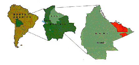
Figure 1: Proposed Park. The
Kenneth Lee Scientific Reserve (far right, red) would preserve
suspected earthworks that
cover Bolivia’s Beni Region (adapted from CIDDEBENI).
Anthropological El
Dorado
For centuries, the Llanos de Mojos guarded its story well. A shelf of alluvial deposits as much as 3000 meters deep, the savanna was once rumored to house the golden city of El Dorado. Protected by its clouds of insects, its climactic extremes, and its inhabitants’ reputation for fierceness, it was among the last areas in South America reached by Europeans. In 1617, a ragtag band of explorers finally established that El Dorado did not, in fact, exist in the Llanos de Mojos. The Jesuits ruled the area from 1668 to 1767, while disease ravaged the indigenous people.
Even after the destruction wrought by the Spaniards, the Beni hosted a remarkable mosaic of indigenous societies until the mid-20th century. Its cultural diversity—and the relative lack of knowledge of the area— led the Smithsonian anthropologist Alfred Metraux to call eastern Bolivia "the El Dorado of anthropologists" in 1942. "Some of the Indians came in touch with the Spaniards during the First years of the conquest; [but] others even maintain their independence today and are among the few natives of South America who still live as they did before the arrival of the whites."
Despite Metraux's enthusiasm—and the impetus provided by Denevan's later work on the earthworks—the Beni remained largely unexamined. U.S. researchers were put off by Bolivian political instability, by the difficult climate of the area, and by anti-American sentiments fueled by the heavyhanded presence of the U.S. Drug Enforcement Agency in the region. For their part, Bolivian archaeologists focused on the highland civilizations of the Andes, with their enormous, glamorous stone ruins. Only in the 1990s did a Bolivian-American team led by Erickson begin the first long-term archaeological research on the earthworks of the area.
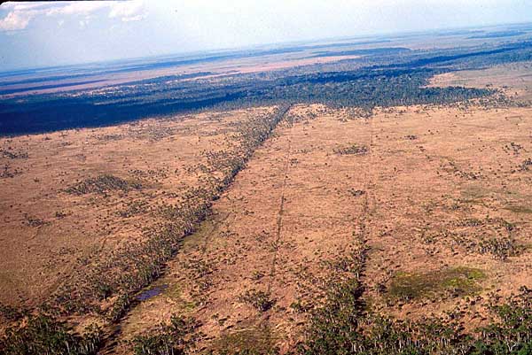
Lines in a landscape. Three
pre-Columbian causeways run between raised mounds in Baures, Bolivia. Trees
grow
on the causeways and mounds,
protected from the savanna's seasonal fires and floods (photography by C.
Erickson).
Cultural mosaic
Climbing to the top of Ibibaté, a forested loma (mound) 18 meters higher than the surrounding savanna, Erickson comes to a bare patch of earth created by a fallen tree. Bending over the uncovered ground, he points out the dark, almost black soil, which is filled with fragments of pottery. Several pieces of pot rim are visible, along with the leg of a vessel shaped like a human foot. Both the richness of the soil and the abundance of the potsherds are typical, in Erickson's view. "Many of the lomas are almost nothing but enormous heaps of sherds," he says. "I've never seen anything like it—10, 20, 30 feet of sherds"
Ibibaté—"big mound" in the language of the local Sirionó Indians—is about 50 kilometers east of Trinidad, the provincial capital. The focus of ongoing study by Balée, Erickson, and a team of Bolivian scientists working with Erickson, Ibibaté is actually a pair of mounds connected by a short earthen wall. At the edge of the lower, southern mound is a Sirionó hunting camp; the higher mound is used for gathering fruit and nuts. Several earthen causeways radiate out like highways from the mound toward other mounds. Bordered by narrow canals, the causeways are about a meter tall, 3 to 5 meters wide, and straight as a rifle shot. Such features are rare in floodplains, according to Denevan, which to him suggested an artificial origin. Indeed, in Balée's opinion, Ibibaté is "as close to a Mayan pyramid as you'll see in South America. ... Beneath the forest cover is a 60-foot [18-meter], human-made artifact."
Although their research is incomplete
and mostly still unpublished, Erickson and Balée have sketched out a rough
outline of what they believe happened here. Ibibaté, like most of the hundreds
of lomas in the Llanos de Mojos, was
initially a much smaller mound, if it existed at all. It was built up, Erickson
says, by the original inhabitants of the Beni, although how and why remain
uncertain. They could have begun by raising parcels of land to grow crops above
the floodwater. Or, according to the late petroleum geologist and amateur archaeologist
Kenneth Lee, they may have created the mounds when, for religious reasons, they
buried their ancestors in ceramic urns and set up housekeeping on top of them.
In either case, the people raised the lomas further by accumulating, garbage,
the walls and roofs of collapsed wattle-and-daub houses, and, especially,
smashed pottery. "The quantity and mass of material deposited indicates
that a lot of people were responsible, creating the mounds over a period of at
least 2000 years," Erickson says, "hazarding a guess" that
Ibibaté typically housed 500 to 1000 inhabitants.
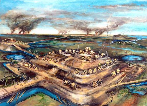
Life in the Llanos. An artist’s conception of a settlement in the Llanos
de Mojos, some 2 millennia ago. (painting by Dan Brinkmeier)
The villages, each on its own island of higher ground, were anything but
isolated. By studying the geographic distribution and variety of the earthworks
and their associated pottery, Erickson's team has tentatively concluded that
the Llanos de Mojos was the home of not just one pre-Columbian people but a
complex mosaic of societies linked by networks of communication, trade,
alliance, and probably warfare. Beginning 3000 to 5000 years ago, Erickson has
written, these cultures erected "thousands of linear kilometers of
artificial earthen causeways and canals, ... large urban settlements, and
intensive farming systems." For reasons that are still not completely
understood, the whole social network unraveled about the time of Columbus or
soon after. Smallpox may well have visited the area—many researchers think that
an epidemic of the disease greatly weakened the nearby Incan empire in about
1525. In addition, Meggers believes that the Beni, like the rest of Amazonia,
was subject to catastrophic droughts.
Erickson's team and local farmers erected their own raised fields to see how they might have worked. They concluded that the original inhabitants of the Beni probably employed traditional agriculture, growing beans, squash, sweet potatoes, and manioc on raised fields; agroforestry, planting groves of palm, nut, and fruit trees; and—perhaps surprisingly—aquaculture. Around the causeways in a northeastern region of the Beni known as Baures, Erickson says, run long, low, zigzag earthen walls that stretch for as much as 3 to 4 kilometers. The structures, he believes, were fish weirs, used when the rainy season covered the savanna with up to half a meter of standing water. Narrow channels up to 3 meters long open at angles in the zigzag. There, woven nets could be used to harvest fish and shellfish, Erickson says. The openings also funneled fish into artificial ponds as much as 30 meters across. In addition, the weirs are piled high with shells from apple snails (the edible gastropod genus Pomacea), possibly discarded after meals. The structures persist, although no one maintains them any longer; even today, the ponds pullulate with fish during the dry season. "They converted the savanna into huge fish farms," says Erickson. "When you see the weirs radiating out from the causeways, I don't think there's any doubt of the intentionality."
Archaeology wars
Others strongly disagree, in terms that mirror archaeology's long-standing disputes about Amazonia. In influential books and articles, Meggers and her husband, the late Clifford Evans, argued that despite its rich flora, the river basin's thin, acidic soils can't hold enough nutrients to permit sustained, intensive agriculture. And that means big, complex societies—which inevitably depend on agriculture—cannot long exist in Amazonia. Indeed, Meggers once proposed that Amazonian villages could contain no more than 1000 inhabitants before collapsing. "We call these cultures 'primitive,' ' she says of contemporary indigenous groups, which are some of the least technologically advanced in the world. "But they are actually remarkable accommodations to severe environmental limits. They show us what's possible there."
When researchers claim that large, complex societies existed in Amazonia, she says, it shows only that "there's a lot of tricky environmental stuff that most archaeologists either ignore or don't know about." Because tropical lands are washed by frequent, heavy rains, she says, the traces of human occupation are flushed through the soil rather than being deposited in neat layers. Thus a place that was intermittently occupied by a few people can seem to have been settled permanently for long periods—the layers are smeared out. "The climate hides evidence of disoccupation," she says. "The charcoal samples get displaced. There's a whole list of pitfalls and problems."
In the early 1980s, Bernard Dougherty and Horacio Calandra, two Argentine archaeologists backed by the Smithsonian, excavated several Beni lomas similar to Ibibaté, though smaller. They concluded that the mounds were "not difficult to ascribe" to natural forces, especially "fluvial activity." In their view, the causeways and raised fields of the Llanos de Mojos were probably created by a higher culture, perhaps from the Andes, which set up short-lived colonies that winked out under ecological pressure. “It seems that here, as in other parts of the world, the environment had the winning ace from the beginning. Calandra and Dougherty wrote in 1984. In his dissertation, Langstroth argued, in parallel, that the isolated forests were not created by humans. “They were created by fragmentation and erosion of natural levees," he says. “It sounds nice to give people credit for doing wonderful things, but the evidence isn't there."
Erickson's critics
have also pointed out that structures like lomas, causeways, and raised fields require sustained mass labor,
which in turn requires the coercive, centralized authority and hierarchical
division of labor characteristic of state-level societies. Yet in lowland
Amazonia, as Erickson concedes, there is "no good historic or ethnographic
evidence" for such vertically organized states.
Erickson has a
different explanation: The earthworks, he suggests, were erected by
"heterarchical" societies: groups of communities, loosely bound by
shifting horizontal links through kinship, alliances, and informal
associations. "There are some people working in South America who take a
look at massive complexes of raised fields and say. This has to be organized by
a complex polity,' " reports Peter Stahl, an anthropologist at the State
University of New York, Binghamton. "Whereas Clark [Erickson] says, 'No,
this is the accumulated landscape capital of generations of farmers who built
it more or less on their own.' "
Like Erickson,
Roosevelt believes that sophisticated pre-Hispanic cultures occupied the middle
and lower Amazon areas she has studied. With abundant fruit, nuts, edible palm,
and fish, she says, river-basin peoples "had lots of options that people
in [less naturally rich] places like central Mexico didn't have— they could
always run away and do what they wanted." The result, in her view, was
"much less coercive" societies—“more like epic chiefdoms, where the
leaders sponsor buildings and ceremonies"—somewhat like the wealthy,
relatively relaxed Indian cultures in the Pacific Northwest and California.
“And we're still learning," she says, “about how they shaped this
wonderful landscape they bequeathed us."
Researchers who deny
the importance of the pre-Hispanic Beni cultures, Erickson explains, have been
misled by “archaeology's traditional Fixation on individual sites." The
traditional method of digging individual sites and measuring their contents is
unlikely to produce clear data, Erickson says, for the very reasons Meggers
cites: The area's heavy rainfall mixes up sedimentary layers, and the local
practice of heaping up earth to create mounds and causeways farther jumbles the
archaeological record. So, he argues, traditional site excavation must give way
to a study of the landscape as a whole—“treating the landscape like an
artifact, as if it were a piece of pottery." Such “landscape
archaeology" uses nontraditional tools, including aerial photography,
radar imagery, and multispectral satellite imagery, to prepare digital maps of
large areas. "My main critique of the site concept is that it implicitly
puts edges around each site. But here in the Beni, the 'sites' go on forever--the whole landscape has been organized and designed."
A flight in a small
plane over the area makes Erickson's meaning clear. “This group of islands is
connected with that one, but not those," he says, shouting over the noise
of the propellers. “There's a relationship there. -. The raised fields are all
aligned in a north-south direction. The landscape is telling us something."
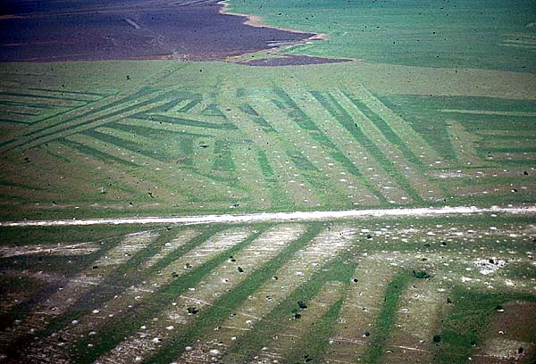
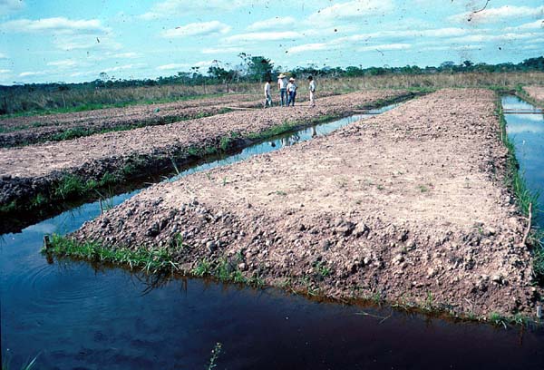
Re-Creating Prehistory: A
patchwork of ancient raised fields (above). Clark Erickson's team and
local
farmers studied how such
fields work by erecting their own (below) (Photographs by C. Erickson)
Ecological adaptation
Erickson and others
argue that the Beni mound builders began a process of ecological change in the
region that continues to this day. Balée, for example, says the Beni, in his
view, was “not favorable for well-drained tropical forests until after people—
deliberately or not—made it favorable for them" by raising the mounds
above the floodwaters and enriching the soils by burning, mulching, and
depositing wastes. After the original inhabitants of the lomas disappeared 300
to 600 years ago, the mounds were presumably colonized by forest. When the
Sirionó arrived on the scene—Balée believes, on linguistic evidence, that they
emigrated to the Beni about 3 centuries ago, probably from the south—they
altered the composition of these forests to suit themselves, creating what
Balée calls “artifactual forests."
As evidence, Balée
points to one of the most common tree genera on the loma: Sorocea, which
is used by the Sirionó to make beer. In the Beni, Sorocea is found only
on the mounds, not in the surrounding land with standing water, which to Balée
is "strong evidence" that people brought it to the lomas. Similarly,
the spiny palm (Astrocaryum murumuru), which has many indigenous uses,
is much more common on the lomas than elsewhere—“there's 112 of these
here," Balée says at Ibibaté, “as opposed to something like 15" in an
equivalent nonmound area.
“There is more forest
in the Llanos de Mojos because of people in pre-Hispanic times than in spite of
them," Balée says. To him, this indicates "that there is no necessary
incompatibility between human use and biodiversity in the tropics," and he
hopes that conservationists, who sometimes view human actions as a priori
destructive, will not seek to curtail the Indians' freedom.
Active efforts are
being made to protect the Beni and its remaining indigenous peoples from
over-development. After some hesitation, the Bolivian government has
established more than a dozen reservation-like areas for Indian groups,
although in some cases they provide little actual protection. Partially
overlapping the indigenous areas for the Baures and ltonama peoples—the two
easternmost reserves—is a proposed Kenneth Lee Scientific Reserve, named after
the U.S. petroleum geologist whose vigorous advocacy of the Beni inspired many
researchers, Erickson among them. (Lee died in 1997.) The Centro de
Investigación y Documentación para el Desarrollo del Beni, a Trinidad-based
nonprofit organization that seeks to develop the area in ways that would
benefit indigenous groups, favors the plan. Meanwhile, some environmental groups
would like UNESCO to create a World Heritage Site in the eastern Beni. There
are already three such reserves in Bolivia, though none in the Llanos de Mojos.
Presumably, the first priority in such a management scheme would be
conservation—a stance that worries Denevan.
“The Indians created
the environment we're trying to protect," he says. “They should get to
stay there while we're learning what they did." -CHARLES C. MANN
4 February 200 Vol287:786-789 SCIENCE http://www.sciencemag.org/
© Charles C. Mann
Used by permission of the author, Charles C. Mann. Photographs by Clark L. Erickson. Painting by
Dan Brinkmeier. Map by CIDDEBENI.
Reprinted with permission from Earthmovers of the Amazon, Science,
4 FEBRUARY 2000 VOL287:786-789.
Copyright 2000 American Association for the Advancement of Science.
Readers may view,
browse, and/or download material for temporary copying purposes only, provided
these uses are for noncommercial personal purposes. Except as provided by law,
material may not be further reproduced, distributed, transmitted, modified,
adapted, performed, displayed, published, or sold in whole or part, without
prior written permission from the publisher.
A “News Focus”
article from SCIENCE
4 FEBRUARY 2000
VOL287:788
The Good Earth: Did
People
Improve The Amazon Basin?
By
Charles C. Mann
The debate over the
existence of a major prehistoric society in the Beni area of Bolivia (see main
text) is tied to a broader dispute over whether the Amazon Basin has ever been
able to support big, complex cultures. That dispute centers largely on soil
quality. Despite its rich flora, Amazonia has many thin, aluminum-rich soils
that can't hold nutrients and are toxic to crucial soil bacteria. Societies
that try long-term farming, say Smithsonian archaeologist Betty J. Meggers and
others, will destroy the soil completely—and their resource base along with it.
But evidence has gradually accumulated that the picture of the Amazon as a
"counterfeit paradise," to use Meggers's phrase, may be overly
simple.
Amazonia is usually
divided into the várzea or floodplain, which occupies perhaps 2% of the basin's
7 million square kilometers, and the terra firme, the never-flooded uplands
that comprise everything else. (Oddly, the Beni counts as uplands because 'it's
flooded by rain, not river water.) According to Nigel J. H. Smith, a geographer
at the University of Florida, Gainesville, "everyone agrees" that
much of the várzea is fertile. What's in question is the fertility of the
uplands. For more than 150 years, says Smith, individual researchers have
reported that the terra firme contained pockets of good land—in particular the
terra preta do indio (Indian black earth) often found beneath ancient
indigenous settlements. In 1980, Smith summarized the evidence, including his
own discoveries, for the prevalence of upland terra preta. "I got two
reprint requests for that article," he says, laughing. "Nobody was
ready to hear it."
One reason for the
neglect, according to Emilio F. Moran, an anthropologist at the University of
Indiana, Bloomington, is what he calls "the problem of scale."
Three-quarters of the upland soils are indeed poor, he says. As a result,
large-scale maps correctly show the basin as a wash of impoverished land. But
on a smaller scale, Moran says, the land is dotted with patches of terra preta.
"Even if it only covers 10% of the terra firme" he says. "the
Amazon 's so big that 10% represents an enormous resource base. It's bigger
than France."
The 10% figure, Moran
says, is just a guess. Fewer than 1000 soil samples from the Amazon have ever
been analyzed, according to William L. Woods, a geographer at Southern Illinois
University in Edwardsville. Last year. Woods and Joseph 1. McCann of the New
School University in New York City published their study of the soils along the
Tapajós River, a major tributary of the middle Amazon. They found scores of
black-earth sites ranging from 0.5 to 120 hectares, most of which were still in
use by local farmers. Indeed, Woods and McCann believe that indigenous
agriculture, far from destroying the soil, actually improved it.
In the past, archaeologists
usually argued that terra preta represented ancient deposits of volcanic ash or
former pond bottoms. Based on chemical analyses—and the constant presence of
pottery—most researchers now believe that the black earth is created from old
middens (deposits of waste). This explanation is incomplete, Woods and McCann
say. They distinguish between terra preta proper, which they define as the soil
directly around human settlements, and what they call "terra
mulatta," slightly lighter soils that surround terra preta and often cover
areas 10 times larger. The terra preta is the remains of ancient middens; the
terra mulatta is soil used for agriculture—soil that has been deliberately
altered by mixing with wood ash.
Farmers burned off
the forest cover of their fields. Woods explains, then tilled in the cinders.
The ash reduces the acidity of the soil, which in turn reduces the activity of
the aluminum ions, fostering microbial growth. “In addition," he says,
the ash "greatly increases the nutrient-retention capacity."
“I can't tell you how
much of the Amazon Basin has been changed,” Woods says, “but I can tell you
that enormous areas have been modified, which implies a lot of people doing
it." Woods would not be surprised, he says, if Amazonia turned out to have
about the same percentage of excellent arable land as, say, the United States.
Smith agrees: "The soils were a constraint, but people overcame them.
Amazonia may have been a counterfeit paradise to start with, but it sure
doesn't sound like it was one when they were finished with it." –Charles
C. Mann
4 February 200 Vol287:788 SCIENCE www.sciencemag.org
© Charles C. Mann
Used by permission
of the author.
Reprinted with permission from Earthmovers of the Amazon, Science,
4 FEBRUARY 2000 VOL287:786-789.
Copyright 2000 American Association for the Advancement of Science.
Readers may view,
browse, and/or download material for temporary copying purposes only, provided
these uses are for noncommercial personal purposes. Except as provided by law,
material may not be further reproduced, distributed, transmitted, modified,
adapted, performed, displayed, published, or sold in whole or part, without
prior written permission from the publisher.