|
PERSPECTIVE
Political maps and cultural
territories
The earliest boundary
between India and Bangladesh separated peoples of the hills
and plains.
by David
Ludden
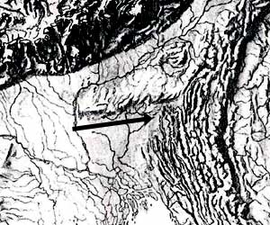
The delta
leading up to the Meghalaya hills.
|
The international boundary between India and
Bangladesh came into being in 1947, but some of its segments
have much older histories. The oldest segment lies below the
mountains of Meghalaya and forms the northern border of the
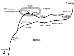
Sunamganj Zila of Bangladesh.This boundary runs east and west,
cutting across many short rivers, whose names elude most maps,
one being the Dhamalia river, which falls from Pandua, in
India, and empties into the Surma River, near the town of
Sunamganj, in Bangladesh. Borderlands of Mughal Bengal had
once spanned the basins of the Dhamalia and other parallel
rivers draining the mountains into plains below, but a
definite geographical divide emerged in 1790, in the Sylhet
district of British Bengal, in the form of a boundary line
that served explicitly to restrict and regulate mobility
between two political territories, defined as the homelands of
two distinct cultures in the mountains and plains,
respectively.
The rationale for inventing this boundary was
an early precursor of the two nation theory, which
eventually informed the partition of British India. At the
same time, the birth of this boundary indicates that
international borders are not homogenous, despite their
appearance on maps as continuous lines. In addition, the local
history of this boundary evokes many others in the old
borderlands of mountains and plains spanning Indias northeast
and Bangladesh, where state borders today have meanings quite
distinct from the meanings enshrined in international law and
in national sentiments.
Once an open terrain
National boundaries are now sacrosanct symbols of
sovereignty, but people who move across them routinely
experience these same boundaries as mere obstacles to
mobility. This experience reflects a much older reality than
national maps, because for most of human history, states had
little power to regulate mobility across borders. For many
centuries, social and cultural boundaries marked the supremacy
of specific groups in particular places, without imposing
restrictions on geographical mobility. Pre-modern territorial
boundaries resembled island shores or edges of forest
clearings more than gated city walls.
Inscriptions record the first boundaries in the
basin of the Surma and Kushiara rivers, which flow through the
Sylhet region (which now includes Sylhet, Sunam-ganj, Maulvi
Bazar, and Habiganj zilas in Bangladesh), after they emerge
from the Barak river in Cachar, in present-day Assam. In the
first millennium CE, Kamarupa kings granted land to brahmins
around the Surma and Kushiara, in places then called Srihatta
and Khanda Kamarupa. These names indicated domains of royal
patronage for Hindu elites whose religious rituals marked
their local boundaries. Even today, in Cachar, rituals around
the temple of Kapiliswar mark such boundaries. Here,
high-caste Hindus worship Siva as Kapiliswar, while others
venerate the site but not the deity. This ritual boundary
suggests that an older settlement of Khasis had been
incorporated by immigrant settlers for whom Hindu territory
emerged as a physical space controlled by brahmins, their
patrons, and their subordinates. Hindu boundaries thus emerged
as frontiers, limits and edges of Hindu ritual and social
order.
Over many centuries, numerous groups drew
boundaries in similar ways in and around the Surma and
Kushiara, forming disparate territories of social order.
Because populations were small and land abundant, people had
ample space to construct new territories, each with its own
boundaries, its own elites and systems of subordination. A
patchwork of territories had emerged by 1303, when Shah Jalal
conquered local rajas and established Islam in Sylhet,
creating a new Muslim cultural boundary. When the traveller
Ibn Batuta met Shah Jalal, in 1346, the Sylhet landscape held
diverse territories of Khasis, Garos, Hindus, Muslims and
others.
Taming the wild
In 1612,
Mughal armies created the first system of state authority in
the region called the Sylhet Sarkar. This was the northeastern
frontier of Bangla Suba (province), with boundaries marked by
the power of a Mughal commander (faujdar) and by state rituals
in which people paid homage and taxes to Mughal emperors.
Thus, the Mughals created a boundary that was new for the
people in this area.
 |
| During the Moghul
period, because land was abundant, people on the
margins of state power could still move away to
remain independent |
| |
Mughal authority also accentuated an existing
boundary between settled farming communities and outsiders
living in the jungle. From ancient times, civilised groups
gave jungle people derogatory names to denote a wild nature.
Such labelling valorised the subordination and expulsion of
jungle people, but at the same time marked their autonomy
within their own territories. Permanent farms, villages,
towns, and cities became landmarks of civilisation, around
which, jungles marked the frontiers of expansive agrarian
societies. States advanced their supremacy by promoting
agriculture, clearing jungle, and conquering, assimilating,
and expelling jungle people.
The Mughals pursued this mission extensively,
because farms, not jungle, provided state revenue, and
farmers, not jungle people, bowed to Mughal authority.
Boundaries of state authority fell at the jungle edge.
Clearing jungles to make farms became a quintessential
imperial project. In the 18th century, Nawab Murshid Quli Khan
and his successors accelerated progress in northeastern Bengal
by granting large tracts of jungle to men who would clear
forest to make farms. Local farmers thus became pioneers
pushing farms and state power together into the jungle, where
jungle people often fought back, making agricultural expansion
a violent process that progressed most rapidly where state
power was most concentrated.
Because land was abundant, however, people on
the margins of state power could move away to remain
independent. Like many groups today designated tribes, Khasi
people (also called Khasia in Bangla) lived in such spaces
of mobility, and from ancient times, had scattered among river
basins to engage in shifting rice cultivation. Ancient Khasis
pioneered rice farming in Vietnams Red River delta; and when
conquered there by Vietnamese, had moved up the Red River,
into Yunnan (China), across Burma into Assam, Bengal and the
Ganga river basin. Also in ancient times, Gangetic agrarian
societies and states began expanding eastward, and each
expansionist wave forced jungle people such as the Khasis to
submit, fight, assimilate, and move.
Bengali societies evolved on the eastern
frontiers of Gangetic expansion, in landscapes inhabited by
numerous non-Bengali peoples, who hunted, farmed, and fished
in the jungles without settling down permanently. The people
living in jungle habitats had distinctive languages,
religions, and social practices, including matrilineal
kinship, which marked them as primitive aliens for agrarian
folk who invested in permanent cultivation, under state
authority. Over the centuries, as agrarian states expanded
across the lowlands, many Khasis and other jungle inhabitants
moved up into forest highlands and mountains, where they
formed independent domains.
Empire in cowry
country
When the English East India Company took
Bengal from the nawabs, in 1757, the old northeastern
frontiers of Mughal Bengal posed many problems. Khasis held
most land north of the Surma and ruled mountains above.
Jaintia Khasi rajas held mountains and lowlands north and east
of Sylhet town. Cachar rajas held the lower Barak valley.
Tripura rajas ruled southern uplands and adjacent plains. In
the lowlands, the English increased taxation as much as they
could, but Sylhet district remained poor revenue territory,
covered with forest.
The old Mughal northeastern frontier also posed
a peculiar monetary problem, because cowry shells were the
only coin. For centuries, these tiny shells from the Maldives
were the cheapest coin all around the Indian Ocean region, and
Bengal was a famous cowry market. But in Bengal, only the
northeast had no metallic coins in its markets, only cowries.
People here imported almost nothing from downstream, except
cowries, which merchants brought upriver on boats that
returned downstream with rice, fish and mountain products. By
1780, limestone was the most important mountain product, and
it came only from quarries in the high northern mountains, in
what is today Meghalaya. Khasi rajas around Pandua controlled
quarries from which limestone came down the Dhamalia on boats
to Sunamganj, a market town on the Surma built in the 18th
century and named for its limestone trade.
|
| In 1789, 4000 Sylhet
taxpayers owned land under Company law; in 1795,
the number was 26,000 |
| |
Cowry currency thus described a monetary
boundary. The Mughals and Nawabs would spend all their Sylhet
revenues inside this boundary, but the English needed to
convert cowries into rupees to serve wider imperial ambitions.
In 1780, the English Collector in Sylhet sought to accomplish
this conversion, without exporting cowries, by using the East
India Companys cowry revenue to finance his private business
ventures. He used state tax revenues to buy limestone in
Pandua, which he sold downstream for rupees that he then used
to remit the Sylhet revenues to the Company treasury in
Calcutta. He focused on limestone, shipped from Pandua to
Sunamganj, and then downriver to Dhaka and Calcutta.
In the 1780s, mountain trades boomed in
mountains and lowlands, between Pandua to Sunamganj, where, at
the time, most land, in the Collectors words, was covered
with an impenetrable jungle and so infested by elephants,
tigers, and other wild beasts that
clearing and cultivation
[was] attended with great difficulty and expense. Elephants
provided most income for the few forest zamindars, who paid
the English revenue. Khasi rajas in the mountains exercised
sporadic authority in the jungles below, and the English could
no more conquer the mountain Khasis than could the Mughals,
for, as the Collector said, you might as well attack the
inhabitants of the moon.
In the 1780s, natural calamity made the jungles
between Pandua and Sunamganj more attractive for lowland
farmers and investors. Massive floods in 1784 and 1787
disrupted life drastically in the plains and mountains, and
famines ensued. More investors focused their attention on land
above the flood line, covered with jungle, even as merchant
activity expanded along routes to the mountains. Pressed for
funds to finance imperial wars, the English became more
willing to use force to increase tax revenues. As a result, a
motley, violent and chaotic mixture of British imperialism and
Bengali enterprise invaded the land north of the Surma, where
prime land for new farms lay in forests filled with people who
never submitted to the Mughals, nawabs or British.
Conflict in the
borderlands
In the 1780s, various kinds of
boundaries defined localities north of the Surma. Ethnic
boundaries surrounded Khasi settlements. State boundaries
marked land where people paid taxes. Social boundaries
enclosed farming communities. All these mingled inside the old
jagir of Omaid Rezah, where generations of Khasis and Bengalis
had formed mixed settlements of people called Bengali Khasis,
who lived in forests, owned farmland, and traded and married
among mountains Khasis as well as among Bengali communities.
North of the Surma, Omaid Rezahs authority
declined rapidly in the 1780s. The English demanded more tax
than he could pay and then divided his jagir among his heirs
and creditors. Merchant power also increased in his old jagir.
New farmers and investors moved into the forest. The English
gave and took away land rights according to peoples ability
to pay taxes. In this context, serious conflict ensued.
Tension erupted first around Pandua, where the
English maintained a small force to protect merchants. In
1783, Khasi mountain warriors seized Pandua and the passes
around. Sporadic warfare continued for seven years, between
Company armies and Khasi rajas around Pandua. In 1788,
conflict began in lowland forest villages north of Sunamganj,
during flood-induced famines. In early 1789, two lowland
Bengali Khasi warrior rajas, Ganga Singh and Aboo Singh,
captured numerous villages and controlled several river
routes. In the summer, rebel Khasis and Bengali Khasis
controlled 137 Bengalee villages, Ganga Singh escaped to the
hills, and Aboo Singh attacked the Pandua fort, killing its
commander.
The English then launched a war on two fronts:
in mountains around Pandua and in jungles behind Sunamganj. By
early 1790, Company troops had conquered most people below the
mountains, and open warfare ended soon after a British
commander ordered the massacre of Bengali Khasis around Ganga
Singhs home village. But by then, the Company had lost Pandua
irretrievably to mountain Khasi rajas.
In November 1791, the 35th Sepoy Battalion left
Sylhet, its mission only half-accomplished. The new state
boundary drawn between British Bengal and mountain Khasi
domains became a reality based on Khasi victories in the
mountains and British victories below. The new border ran
along the base of the mountains and bisected the route from
Sunamganj to Pandua. It marked the northern limit of British
Bengal, which only then extended indisputably to the
mountains, and equally indisputably, did not include Pandua.
A new kind of
boundary
Marking boundaries firmly was not normal
imperial practice at the time, so it required extensive
justification, recorded in official correspondence. First and
foremost, the boundary secured Company territory against
threats to British authority posed by unregulated mobility
between mountains and lowlands. The English drew this boundary
to restrict mobility by defining the northern mountains as
independent Khasi territory. Henceforth, mountain Khasis
officially became aliens in the plains, where all the land
became Bengali territory.
As per the official culture of the Companys
governance, the new boundary separated the races of Khasis
and Bengalis. It imposed restrictions on intercourse and
intermarriages that produced what one official called the
degenerate Race called Bengalee Cosseahs. As one collector
explained, problems addressed by the boundary did not arise
from the inherent character of the Khasi race, but rather
from Khasia and Bengali miscegenation; hence, from interracial
alliances that threatened the Companys territorial order by
mixing lowland popular culture with the wild, unruly culture
of the mountains, where people did not respect state
authority.
The new state border also became a boundary of
free trade. Collectors prohibited European merchants from
operating inside Khasi territory; and they also prohibited the
northern mountain Khasis from trading in Sylhet, while
non-Khasi merchants from Jaintia and Cachar were considered
as quiet and inoffensive, and thus continued to be allowed
free access to markets in Company territory, contingent on
good behaviour.
In addition, the border defined eligibility to
own landed property in ethnic terms. The English prohibited
Khasis from owning land on the grounds that their land had
been acquired illegally, and on the assumption that Khasis
could never abandon mountain methods for establishing property
rights, deemed alien in the plains. Collectors then
expropriated the lowland Khasi landed property rights, already
established under Company law, to make way for Bengalis. The
land market thrived as land buyers acquired state-defined land
rights to support the laborious process of clearing jungle and
creating new farms.
The impact of the new border thus fell most
heavily on Khasis below the mountains. Before 1790, shifting
cultivation, permanent farms, hunting, trading and fighting
were carried out in the open borderlands spanning mountains
and plains, in mixed Khasia and Bengali environs. After 1790,
these mixes faded away under the impact of British authority
and new waves of Bengali colonisation. Government auctions of
Khasi land began in 1792, and a year later, the collector
reported that he had completed sales of all land expropriated
from rebellious Khasi and Bengali villagers, except a
trifling remainder of Cosseah land.
Clearing jungles to make farms took a long
time, however. High taxes slowed the process and encouraged
the new colonists to establish estates that were, so that the
landowners could get enough land cleared quickly by tenants to
pay taxes and reap some profit. Extensive forest zamindar
estates remained covered with forests. Expanses of open jungle
also remained outside the reach of private property, leaving
Khasis some room to manoeuvre. New small estates multiplied
quickly, however. By 1797, land formerly owned by Bengali
Khasis had been occupied by Bengalis very willing and eager
to enter into regular engagements to pay revenue to secure
their property rights. The Collector justified his official
erasure of Khasi rights to this land by saying that Khasis had
held it by force and not only failed to bring it into
cultivation but had scared away farmers, until the Company
secured the area and confined Cosseahs to the hills.
The old Mughal northeastern frontiers witnessed
a rapid increase in privately owned landed property. In 1789,
4000 Sylhet taxpayers had owned land under Company law; in
1795, the number was 26,000, and a year later, it rose to
27,000. Landed estates were mostly very small, and they were
so numerous that by 1800, about 25 percent of the population
of Sylhet district may have lived in landowning families, in
villages that averaged a mere 67 people and four landed
estates (taluks), each representing about 18 people, few more
than one landowning family, its dependents and servants.
The 1790 northern boundary of the Bengal
Presidency, north of the Surma River, gave an old Bengali
boundary a new geographical form. Inside the boundaries of
Bengal, the state defined local elites, who owned bounded
plots of landed property. The states external boundary became
a part of everyday life in villages, where social boundaries
marked the Khasis subordinate, outsider status.
Thus, local histories impart to the former
imperial boundary that now separates Bangladesh and India
meanings quite distinct from those that emerged after 1947.
This boundary defined Bengalis and Khasias as peoples with
separate histories, homelands, and cultural identities, which
mingle in the local history of the borderlands. Here, each
defines the other, and the memory of Bengali Khasis north of
the Surma indicates a distinctive borderland cultural past
outside the reach of the national imagination.
Note: An extensively documented version of
this essay is forthcoming in the Journal of the Asiatic
Society of Bangladesh.
|
